Most people who come to Jibhi know about Raghupur Fort — and this post will tell you why it is worth knowing. The trek to Raghupur Fort starts from the same point as Serolsar Lake — Jalori Pass — but goes in the opposite direction. It is 3 km one way, takes under two hours to climb, and ends at a ridgeline with one of the most unobstructed panoramic views in the Tirthan Valley. On a clear morning in May, you can see Himalayan peaks well beyond 5,000 m from the top. This guide covers everything you need to know — the trail, the history, the views, what to carry, and how it compares to Serolsar Lake.
Before we dive into the history and the climb, here is a quick look at the trek logistics to help you plan your journey:
Detail | Info |
Starting point | Jalori Pass |
Trek distance | 3 km one way |
Total distance from Jibhi | 16km (13 km by road + 3 km trek) |
Difficulty | Easy to moderate |
Time required | 1.5–2 hours up, 1–1.5 hours down |
Highest point | ~3,400 m |
Best season | April–June, September–November |
Entry fee | None |
Guide required | No |
Getting to the Raghupur Fort Trailhead
The trek starts at Jalori Pass, approximately 13 km from Jibhi by road. The drive from Jibhi takes 35–50 minutes depending on road conditions — the road climbs sharply with tight hairpin bends, so take it slow.
From Jibhi: Take the main road toward Shoja. Jalori Pass is well-signed. The road is paved throughout and accessible to all vehicles including hatchbacks.
Parking: There is parking area at Jalori Pass. On weekends in peak season it fills up — arrive by early to secure a spot close to the trailhead.
About Raghupur Fort — A Bit of History
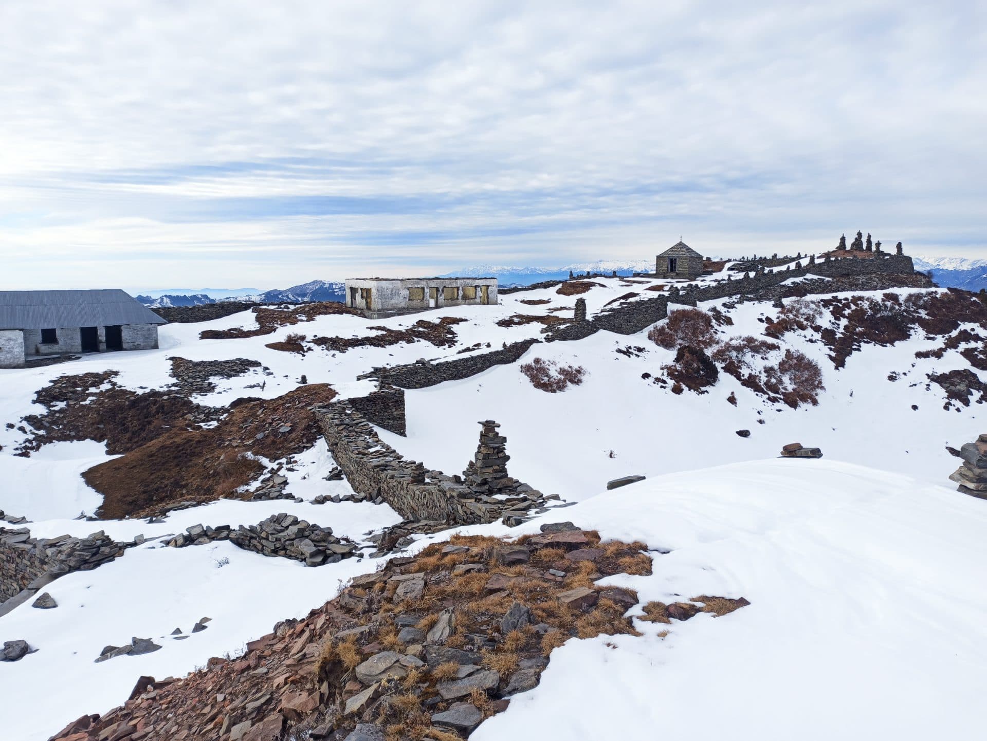
The fort ruins at the top of the ridge are believed to have been built by the rulers of Mandi state, constructed at this elevation to serve as a strategic watchtower over the valleys below. From the top you can understand exactly why — the ridge commands a view of every approach to the pass.
The fort itself is not restored. What remains are stone walls, some structural foundations, and fragments of what was once a significant fortification. There is no museum, no signage, and no ticketing — just the ruins and the sky. For anyone who values atmosphere over architecture, this is preferable to a polished heritage site.
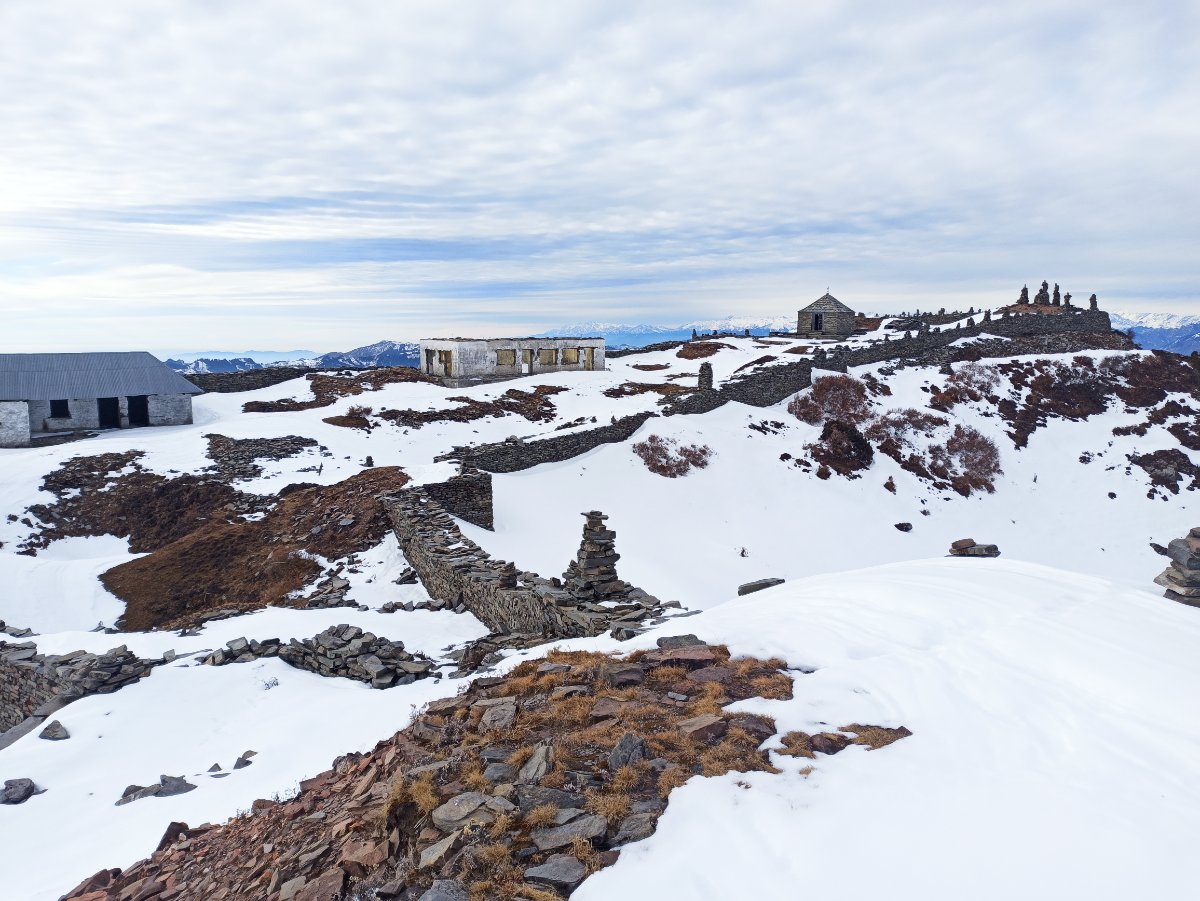
Image : Stone wall ruins and structural foundations of Raghupur Fort
Navigating the Trail: From Forest to Meadow
The trail begins at the right side of Jalori Pass and immediately enters forest. The first kilometre is through dense oak and rhododendron, the canopy thick enough that it stays cool even in June. The path is well-worn and easy to follow — you will not need a map or GPS.
Around the halfway mark the forest begins to thin and the trail opens into a sloping meadow. The ridge becomes visible ahead. The climb steepens slightly here — not difficult, but you will feel the altitude if you have come directly from the plains. Take your time.
The final 500 metres before the summit is open ridgeline. The wind picks up and the views begin opening on both sides. The trail ends at the ruins — a flat area of stone walls with a drop on three sides and the full arc of the Himalayan range laid out in front of you.
On a clear day the view from Raghupur Fort is among the best accessible by an easy trek anywhere in Himachal Pradesh. You are not enclosed by forest or valley walls — you are on a ridge that sees everything.
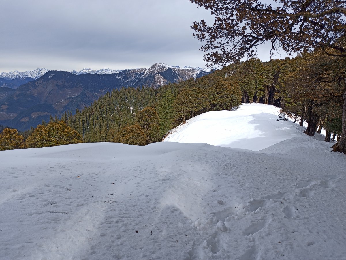
Image: Raghupur fort trail through forest coverd by snow in winter
The Views
The summit offers a near 360-degree panorama. Looking north and northeast you can see snow peaks clearly on any morning with good visibility. The Sainj Valley opens to the west, the Tirthan Valley stretches south, and on exceptional mornings you can see the high ranges above Kinnaur to the east.
Sunrise from Raghupur Fort is worth the early alarm. If you reach Jalori Pass by 6:30 AM and are on the ridge by 8 AM, the light is low and horizontal and the peaks glow before the haze builds. By 11 AM the sky is bright but flat. By afternoon it is often hazy. Come early.
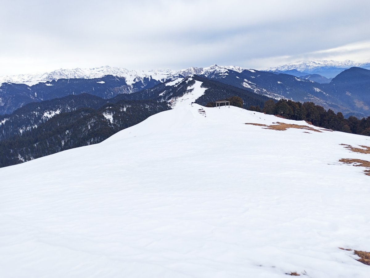
Image: 360 View of Dhauladhar ranges. from raghupur fort
How Difficult Is It?
The trek is beginner-friendly with no technical sections. The uphill is consistent but never steep. Children above 8 years old manage it comfortably. The altitude at the summit (~3,400 m) can cause mild breathlessness for people arriving directly from low altitudes — rest and take it at your own pace.
The return walk takes noticeably less time than the ascent — most people come down in 50–70 minutes.
What makes it harder than it looks: The altitude. If you have come from Delhi the day before and are sleeping at 1,600 m in Jibhi, your body is adjusting. Do not rush the uphill. Drink water consistently.
Best Time to Trek
April to June: Best overall conditions. Trail is clear, views are sharp, rhododendrons in bloom in April. June mornings are excellent before afternoon haze builds.
September to November: Post-monsoon clarity makes October the single best month for views. The forest turns colour and the peaks are exceptionally clear after the summer haze clears. This is when photographs from the summit look unreal.
Monsoon (July–August): Trail is slippery and visibility poor from cloud cover. Not recommended.
Winter (December–March): Trail may be snow-covered. Jalori Pass road can close in heavy snowfall. Check conditions before attempting.
Raghupur Fort vs Serolsar Lake — Which One to Do?
This is the most common question at Jalori Pass.
Raghupur Fort | Serolsar Lake | |
Distance | 3 km one way | 4 km one way |
Time | 1.5–2 hrs up | 2–2.5 hrs up |
Trail type | Ridgeline, open views | Forest, lake destination |
Crowd level | Moderate to high | Low |
Best feature | Panoramic Himalayan views | Sacred lake, forest atmosphere |
Physical demand | Moderate (uphill, altitude) | Easy to moderate |
Best for | Views, photography, early morning | Nature walk, lake experience |
Choose Raghupur Fort if: Views are your priority, you prefer open ridgeline terrain, or you are doing a morning trek and want the best possible light.
Choose Serolsar Lake if: You want a destination with a clear endpoint, prefer forest walking, or are trekking with children who do better on flat terrain.
Can you do both in one day? A small number of guests do cover both treks in a single day. It is possible but only realistic if you are comfortable with 14–16 km of combined trekking, start from Jalori Pass by 7–7:30 AM, and keep a steady pace. Most people who attempt this are experienced trekkers who treat it as a full-day challenge. For everyone else, splitting across two days is the right call — and gives you a genuine reason to stay two nights.
What to Carry
Water: minimum 1.5 litres per person — no water sources on trail
Snacks or a packed lunch
Light jacket even in summer — the ridge is significantly windier than the pass
Trekking shoes with grip — trail can be muddy after rain
Sunscreen and sunglasses — no shade on the upper ridgeline
Fully charged phone
Cash — Patchy network for UPI Payments.
Practical Notes & Facilities
The facilities at Jalori Pass have seen a major upgrade recently. While basic tea stalls still exist, you will now find:
HP Tourism Shops: There are now well-maintained, permanent shops at Jalori Pass, often leased by Himachal Tourism, offering a more structured stop for travelers.
Local Artisan Stalls: You will see mini-stalls run by locals selling handmade crochet items, mufflers, and traditional woollens—perfect for a quick souvenir before or after your trek.
Toilets: In addition to the basic facility at the parking area, the newer tourism-managed shops have improved access to cleaner facilities.
Where to Stay Before the Trek
Shoja: The Strategic Midpoint: For the shortest possible commute, Shoja is the best option as it sits directly in the center between Jibhi and Jalori Pass. Staying here allows you to reach the trailhead quickly while still being close to the cafes and culture of the valley.
Jibhi Village: Staying in Jibhi puts you approximately 1 hour from Jalori Pass. It is a great base if you want to be close to the main market, though you should plan for an earlier start to ensure you reach the parking area by 8 AM.
Winterfell: While Shoja is the most central spot, staying in Jibhi or the Tandi hilltop is worth the extra 1-hour drive for the better views. If you're looking for a reward after the trek, Winterfell offers standalone units and private hot tub treehouses starting at ₹4,500/night. You can check availability directly at winterfelljibhi.com/stays
Frequently Asked Questions
How long does the Raghupur Fort trek take?
The uphill takes 1.5 to 2 hours at a comfortable pace from Jalori Pass. The return takes 1 to 1.5 hours. Include 20–30 minutes at the summit for rest and views. Budget 4 hours total for the full return trip from Jalori Pass.
Is Raghupur Fort trek suitable for beginners?
Yes. There are no technical sections, no river crossings, and no scrambling. The trail is a consistent uphill walk on a clear path. The main challenge is altitude — if you are arriving from low altitude, go slowly and drink water regularly.
Is there an entry fee for Raghupur Fort?
No. The trek and the fort ruins are free to access. No permits are required.
Is Raghupur Fort better than Serolsar Lake?
They are different experiences rather than one being better. Raghupur Fort gives panoramic Himalayan views from an open ridge. Serolsar Lake gives a sacred forest lake experience. Both are worth doing — ideally on separate days.
Raghupur Fort Height and Altitude
The Raghupur Fort altitude is approximately 3,400 meters (~11,155 feet) above sea level . This significant Raghupur Fort height makes it one of the highest points in the region, offering a near 360-degree panorama of the Himalayan range. Because of this altitude, you may feel mild breathlessness if you have just arrived from the plains, so it is important to take the climb slowly.
Raghupur Fort Weather and Best Time to Visit
The Raghupur Fort weather is best for trekking between April to June and September to November . During the summer months, the trail is clear and the mornings are sharp before the haze builds up in the afternoon. October is often considered the single best month for visibility, as the post-monsoon air is exceptionally clear. Avoid July and August.

