Kullu District · Banjar Valley · Himachal Pradesh
Jibhi, Himachal Pradesh
Complete Destination Guide (2026)
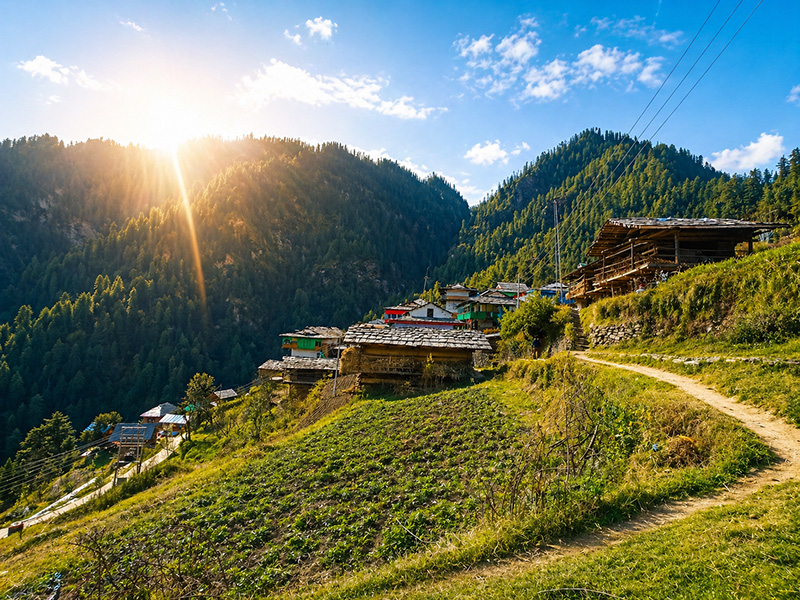
There is a moment on the road after Banjar when the valley narrows, cedar trees rise on both sides, and the noise of the highway disappears entirely. That is usually when first-time visitors realise that Jibhi, Himachal Pradesh is unlike anything they expected from a hill destination. No mall road. No traffic circles. No rows of identical hotels. Just a mountain village built around water, forest, centuries-old Kathkuni wooden homes, and a pace that slows down almost immediately on arrival.
This guide covers everything about Jibhi in one place — where it is, its altitude, what to do, when to visit, how to reach, what to eat, practical tips that most guides miss, and what kind of traveller it suits.
Altitude
~2,250m
From Delhi
500 km · 11–12 hrs
Best time
Mar–Jun · Oct–Nov
Ideal stay
2–4 nights
At a Glance
Jibhi Quick Facts
Location
Banjar tehsil, Kullu District, HP
Jibhi Altitude
~2,250 m (7,382 ft)
Distance from Delhi
500 km · 11–12 hrs
Distance from Chandigarh
~230 km · 6–7 hrs
Distance from Manali
~102 km · 3–4 hrs
Distance from Shimla
~158 km · 5–6 hrs
Nearest Town
Banjar (8 km)
Nearest Airport
Bhuntar, Kullu (~56 km)
Famous For
Jalori Pass, Kathkuni heritage, Treehouses
Best Trip Length
2–4 nights
Best Time
Mar–Jun · Oct–Nov
UNESCO
GHNP buffer zone — World Heritage since 2014
Location
Where is Jibhi?
Jibhi is a mountain village in Kullu district, Himachal Pradesh, situated in the Banjar Valley — part of the broader Tirthan Valley belt. It lies approximately 8 km from Banjar town, 13 km from Jalori Pass, and serves as one of the gateways to the Great Himalayan National Park buffer zone.
Many people searching for Jibhi assume it is near Manali. It is not — and that matters. Jibhi sits on a quieter, less-travelled side of Himachal, off the main Manali highway, away from the heavy tourist movement that defines Shimla and Kasol in peak season. The road to Jibhi branches off at Aut, crosses the Beas River, and follows the Tirthan River upstream through increasingly narrow and forested terrain.
Because of this geography — set back from the highway, accessed through a river valley — Jibhi has retained a character that more accessible Himachal destinations have largely lost.
Standard Route
From Delhi
500 km · 11–12 hrs
From Chandigarh
~230 km · 6–7 hrs
From Manali
~102 km · 3–4 hrs
From Shimla
~158 km · 5–6 hrs
Critical turn: at Aut, take the road toward Banjar before the tunnel. The Aut Tunnel leads to Manali, not Jibhi.
Elevation
Jibhi Altitude and What It Means
The Jibhi altitude is approximately 2,250 metres above sea level (around 7,382 feet). As you climb toward Jalori Pass (3,120m) or Raghupur Fort (3,540m), the physiological demand increases noticeably — stay hydrated and pace your ascent. But at the village level, no acclimatisation is needed for most people arriving from the plains.
Nearby areas like Sojha (8 km, higher) and Jalori Pass (13 km, 3,120m) are noticeably colder and windier than the village — pack layers even for a day trip.
Summers stay genuinely cool
Daytime temperatures in May reach 22–25°C while plains cities push 40°C+. Nights drop to 9–15°C. The altitude makes mornings crisp regardless of season.
Nights are cold year-round
Even in June, evenings drop to 10–12°C. Pack layers regardless of when you visit — a light fleece is non-negotiable.
Winters are cold
November through February sees temperatures close to or below freezing at night. Jalori Pass receives significant snowfall and typically closes.
No altitude sickness risk at the village
2,250m is well within the comfortable range for most people arriving from sea-level cities. The risk begins only as you approach 3,000m+ at Jalori Pass and Raghupur Fort.
Character
What is Jibhi Like?
Jibhi is not a “cover everything in one day” destination. The village has traditional Himachali wooden homes with slate roofs — built in the Kathkuni style, layers of deodar timber and dry stone without mortar — forested slopes, and a small stream running through it. The main market is compact: a handful of cafes, a pharmacy, a few guesthouses, and a waterfall trailhead. Beyond the market, roads branch toward different villages and elevations, each with its own character.
Mornings tend to be misty and quiet. By mid-morning the light breaks through the trees. Evenings go still very quickly after sunset. The air carries damp wood and pine, and in winter the faint smell of woodfire smoke from nearby homes. This atmosphere is not engineered for tourists — it is simply what the valley is.
Jibhi suits
Couples, families who enjoy nature, solo travellers, and people working remotely. It does not suit travellers who need constant stimulation, resort-style infrastructure, or nightlife. There is no party scene here — and that is the point.
Activities
Things to Do in Jibhi
Treks, waterfall walks, heritage towers, serpent temples, and cafes — Jibhi rewards exploration at your own pace.
1 km from market · 20–30 min walk
A short walk through moist forest with wooden bridges and mossy stone. Go before 9am — by midday the trail gets busier and loses its quiet. The waterfall sits in a dense green pocket. Easy trail, suitable for all ages.
Full guide →13 km from Jibhi · 3,120m
The road climbs steeply through dramatic cedar and oak forest and opens into wide mountain views at the top — Kullu valley on one side, Tirthan valley on the other. Open April to November. Only experienced hill drivers should attempt the drive; otherwise hire a local Gypsy vehicle.
Full guide →3 km from Jalori Pass · 3,540m
Steeper and more physically demanding than the Serolsar route. The trail passes alpine meadows and ends on a ridgeline with 360-degree views — some of the widest in this part of Himachal. About 45 minutes one way. Start by 8:30am if combining with Serolsar Lake in a single day.
Full guide →5 km from Jalori Pass · 3,100m
A mostly flat trail through ancient oak and deodar forest — in May, the forest floor is carpeted with wildflowers. The Budhi Nagin temple at the lake edge is sacred: local folklore holds that the goddess resides in the lake's depths, and birds keep its surface clean by picking up any debris that falls in. Allow 4–5 hours round trip.
Full guide →1.5 km from Jibhi market
Turquoise-green water pooling between boulders in a forest clearing — a brief downhill hike from the market road. Best visited in post-monsoon season (September–October) when the water is clear. Few people on weekdays.
Full guide →Village hike · not accessible by hatchback
A 17th-century tower built by King Dhadhu using Kathkuni technique — deodar timber and dry stone without mortar. Before the 1905 earthquake it stood seven storeys; five remain today at roughly 20 metres. Still the tallest traditional structure in the Western Himalayas. The interior is closed to outsiders, but the exterior alone justifies the walk.
Full guide →2.5 km from Bahu village · 9 km from Jibhi
A trail through a quiet meadow to the Balu Naag (serpent deity) temple above Bahu village. Significantly less visited than the Jalori routes — this is the trail you take when you want Himalayan quiet without other hikers. The 'wood trail' aesthetic is unlike any path in this area.
Full guide →Near Gushaini · 10–15 km from Jibhi
A 2–3 hour round-trip walk through lush forest near Gushaini, accessible on the drive toward the GHNP. Combine it with the Sai Ropa nature learning centre visit or a permit for GHNP core zone entry. Good for a second-day full-valley drive.
Full guide →Café Days & Slow Time
No plan neededIn & around Jibhi market
Forest Bean, and Openbook Coffee are the most-recommended — wooden interiors, valley views, stone-oven pizza alongside local chai. But the best use of a morning in Jibhi involves no specific plan: a long breakfast, a book, the sound of water from somewhere nearby.
Living Heritage
Kathkuni Architecture
The houses of the Banjar Valley don't just look old. They were built to survive earthquakes that flatten modern constructions. This is Kathkuni — alternating layers of deodar timber and dry stone, no mortar, no cement. A building technique perfected over centuries that gives these structures a structural flexibility modern materials cannot replicate.
When the 1905 Kangra earthquake devastated this region, Kathkuni buildings remained standing. The same principle governs the construction of temples, watchtower forts, and ordinary homes across the valley. What looks like a rustic aesthetic is actually engineered resilience — the result of centuries of trial and observation in an earthquake-prone landscape.
The Banjar Valley is one of the last places in Himachal where this tradition remains a living practice, not a museum exhibit. You will see it in the homes you pass on any village walk — not just in the famous tower at Chehni.
No mortar. No cement.
Kathkuni construction layers deodar timber with dry stone — nothing binding them except gravity and engineering. A technique perfected over centuries in the Banjar Valley.
Built to survive earthquakes
The flexibility of this wood-and-stone system makes it seismically resilient. The 1905 Kangra earthquake that devastated the region left Kathkuni structures standing where modern constructions failed.
Chehni Kothi — 17th century, still standing
Built by King Dhadhu, the tower reached seven storeys before 1905. Five remain today at roughly 20 metres — the tallest traditional structure in the Western Himalayas. The interior is closed to visitors; the exterior is worth the hike to Chehni village.
Shringa Rishi Temple, Bagi
Below Chehni, the temple in Bagi village is built in the multi-tiered pagoda style — heavily carved wooden panels illustrating mythological narratives. The presiding deity is Shringa Rishi, considered the guardian of the Banjar Valley.
Sacred Geography
The Spirit of the Banjar Valley
Before hotels arrived in Jibhi, the valley had a different kind of guardian. The cultural identity of this place is inseparable from its spiritual geography — deities are considered the true owners of the forests, water sources, and mountain passes.
Jibhi village · short meadow trail
Sheshnag Temple
A wooden temple estimated to be over 500 years old, dedicated to Sheshnag — the serpent deity worshipped alongside Shringa Rishi in the valley. The trail passes through a small meadow and takes less than 20 minutes from the market.
Serolsar Lake · 3,100m
Budhi Nagin, Serolsar Lake
The goddess at the edge of Serolsar Lake is Budhi Nagin — considered the mother of all serpent deities. Local folklore holds that the depth of the lake is unknown and that birds keep its surface clean, picking up any debris that falls in. The lake has a stillness that feels earned rather than decorative.
Throughout Banjar Valley
Shringa Rishi — legend of the valley
The valley's spiritual identity is anchored to the sage Shringa Rishi (Rishyasringa), who performed the Putrakameshti Yagna for King Dashrath of Ayodhya — leading to the birth of Lord Rama. The Banjar Mela, held annually in Baggi village, is dedicated to him. Deities from surrounding villages are brought together in a procession before the four-day fair begins.
Great Himalayan National Park — UNESCO World Heritage
Jibhi sits within the buffer zone of the GHNP — a UNESCO World Heritage Site since 2014, covering 1,171 sq km. The park is home to over 375 fauna species including the Snow Leopard, Himalayan Black Bear, and Western Tragopan (a rare pheasant). The Tirthan River is one of the few un-dammed rivers in Himachal Pradesh, which is why wild Brown and Rainbow Trout still survive here. Permits for the GHNP core zone are issued at the Sai Ropa forest office near Banjar; a registered local guide is mandatory.
Beyond the Village
Emerging Areas Near Jibhi
Jibhi village was the original draw, but the surrounding area has expanded significantly in where travellers explore and stay.
Tandi
5 km from Jibhi
·Hilltop — higher than village
A hilltop settlement with wide views of the valley below. Quieter than Jibhi village and a preferred location for private cottage and treehouse stays. Winterfell has a standalone unit here — the duplex sleeps up to six.
Explore Tandi →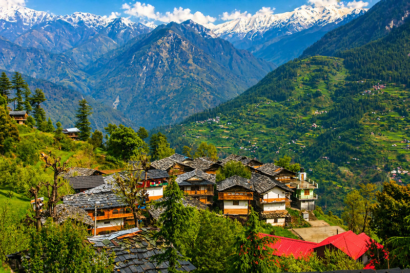
Bahu
9 km on Gadagushaini road
·Similar to Tandi
Faces a different direction from Tandi, with views covering the full Jibhi valley, Jalori Pass in the distance, and the Tirthan Valley ranges. Property development here is newer and fewer — which is its main appeal right now.
Explore Bahu →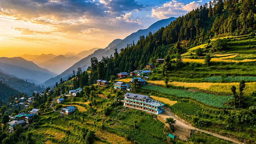
Sojha
8 km from Jibhi
·Noticeably higher than Tandi and Bahu
The defining feature is visibility of snow-capped ranges throughout the year — the kind of view the village of Jibhi itself cannot offer. A small settlement that until recently was mostly a pass-through for trekkers heading to Jalori Pass, now drawing its own visitors.
Explore Sojha →Seasonal Guide
Best Time to Visit Jibhi
Each season in Jibhi offers a distinct experience. Here is what to expect and when to come.
Mar – Jun
Peak Season
15°C – 25°C
Clear skies, green landscapes, and pleasant daytime temperatures. May brings long daylight hours (13.7–13.8 hrs) — ideal for the Jalori treks. Lingud (wild fiddlehead ferns) appears in local kitchens in May, a fleeting seasonal delicacy. Book accommodation 3–4 weeks out for weekends.
Most popularJul – Aug
Monsoon
18°C – 26°C
Very green and atmospheric but with trade-offs: rain, occasional road disruption on the Aut–Banjar stretch, reduced trek visibility, and leeches on forest trails. Jibhi village stays accessible through monsoon. Not ideal for Jalori Pass.
Green & quietSep – Nov
Post-Monsoon
5°C – 20°C
Post-monsoon clarity makes this the strongest season for views and trekking — and for Mini Thailand's turquoise water. The forest starts turning in October. Trout fishing season (September–November) is excellent. Crowds lower than summer. Nights turn cold by October.
Best overallDec – Feb
Winter
−2°C – 10°C
Cold nights, possible snowfall at higher elevations. Jalori Pass closes with heavy snow. Jibhi village stays accessible through most winters. Good for those who want complete quiet and do not mind cold. Carry warm layers — even a bonfire evening requires a proper jacket.
Check road accessItinerary
Jibhi Itinerary
Sample plans for 2-night, 3-night, and 5-night trips. Adjust based on your pace — most guests say they underestimated how much time they'd want to spend just being here.
2 Nights
Weekend Escape
Arrive by afternoon. Settle in. Walk to Jibhi waterfall before sunset — the trail is 1 km and takes 20 minutes. Dinner at a wooden café in the market.
Morning: Mini Thailand walk (1.5 km from market). Afternoon: slow café time. Evening: drive up toward Jalori Pass for the sunset view if the road is open.
Slow morning, pack out by noon, drive via Aut.
Best for a quick reset. Skip the treks — save those for a longer trip.
3 Nights
The Standard Trip
Arrive. Waterfall walk in the evening. Dinner at a local café. Cash top-up in Banjar if needed before arriving.
Full day at Jalori Pass (13 km from Jibhi). Serolsar Lake trek — 5 km one way, 4–5 hours round trip. Budhi Nagin temple at the lake. Back by 4pm.
Raghupur Fort trek from Jalori Pass (3 km, steeper, 360-degree views). Or: Chehni Kothi village walk — the Kathkuni tower up close.
Slow morning. Pack out by noon, drive via Aut.
Covers both treks and leaves time to actually rest.
5 Nights
The Full Valley
Arrive, settle, Jibhi waterfall, Mini Thailand, Sheshnag Temple walk, market exploration.
Jalori Pass full day: Raghupur Fort in the morning (start by 8:30am), Serolsar Lake in the afternoon. Pack a lunch.
Chehni Kothi hike from Bini/Bagi, Shringa Rishi Temple in Bagi. Afternoon: Sojha meadows at sunset.
Drive to Gushaini — Choie Waterfall walk, Sai Ropa GHNP forest complex, optional trout fishing (carry cash for ₹100 permit from Banjar).
Bahu village + Balu Naag Temple trail (2.5 km, very quiet). Final Dham meal at a homestay. Larji Dam confluence stop on the way out.
The trip most guests say they should have booked.
Broader Region
Jibhi is part of the Tirthan Valley
The Tirthan Valley is the larger geographical region — formed by the Tirthan River — that encompasses Jibhi, Tandi, Banjar, Sojha, and the Great Himalayan National Park buffer zone. If you want to understand what's around Jibhi, start with the valley.
Getting Here
How to Reach Jibhi
🚗
By Road
The most common option. Follow NH44 → Chandigarh → NH3 → Mandi → Aut → Banjar → Jibhi. The critical navigation point is Aut — take the turn before the Aut Tunnel toward Banjar. The tunnel leads to Manali. Coming from Shimla, you can also approach via Narkanda and Jalori Pass (158 km, 5–6 hrs, scenic but slower).
Delhi: 500 km · 11–12 hrs · Chandigarh: 230 km · 6–7 hrs
🚌
By Bus
Overnight Volvo and HRTC buses run from Delhi's Kashmere Gate ISBT toward Manali — Aut falls on this route. Book to Aut, deboard there, and take a local cab toward Banjar and Jibhi (35 km, ₹2,000–2,500 for a 4-seater, ₹3,000–3,500 for a 6-seater; ₹100–200 shared with locals). Do not book to Jibhi or Manali directly.
Book ticket to: Aut · Not Manali, not Jibhi
✈️
By Air
Nearest airport is Bhuntar (Kullu-Manali Airport), approximately 56 km from Jibhi. Limited flights operate — mostly from Delhi. Taxi from Bhuntar to Jibhi costs ₹2,000–2,500 (4-seater) or ₹3,000–3,500 (6-seater). Chandigarh Airport is the more practical option for most routes.
Bhuntar (KUU) · ~56 km · ₹1,500–2,000 by taxi (negotiable)
City-specific guides with checkpoints, bus fares, and road tips: Delhi, Chandigarh, Manali, Shimla. Or see the full overview: How to Reach Jibhi →
Local Life
Local Culture & Respectful Travel
Jibhi is a living village, not a resort. Traditional wooden homes, local temples, seasonal orchards, and community ties remain central to how the place functions. Tourism here is relatively recent — most of the growth has happened in the last five to seven years. The Banjar Mela, held annually in Baggi village (dedicated to Shringa Rishi), is a reminder that the valley has its own calendar that predates any guesthouse listing.
Drive slowly through village roads — shared with children, animals, and residents on foot
Keep music low or off when outdoors — the quiet is part of why people come
Dress modestly near temples and in villages
Ask before photographing homes or people — a nod toward Chehni residents goes a long way
Leave trails as you find them. Carry your waste back — waste management in the valley is limited
Food to Try in Jibhi
The culinary culture of Jibhi is rooted in agricultural self-sufficiency — the “Boti” chefs who specialise in ceremonial Dham feasts, the wild ferns that appear on menus only in May, the trout that comes legally only with a permit. Cafes in the market serve everything from cold brew to pasta, but the local dishes are worth seeking out.
Kullu Dham
The ceremonial feast served at festivals. Features Madra (chickpeas slow-cooked with cloves and cardamom), Maah (black lentils), Khatta (tangy tamarind-galgal gravy), and Meetha (sweet rice with dry fruits). Served on dried leaf plates.
Siddu
Fermented wheat flour bread stuffed with walnuts, poppy seeds, or mutton — steamed and eaten with ghee or mint chutney. The closest thing to a signature Jibhi bread.
Lingud (Fiddlehead Ferns)
Wild lingud ferns harvested from the Tirthan forests — available only in spring (May). Cooked as a sabji, this is a seasonal delicacy you will not find year-round.
Chilra
A crepe-like dish made from fermented buckwheat batter. A staple breakfast item in the Tirthan Valley — light, slightly sour, eaten with local chutneys.
Trout
River-caught trout grilled or simmered in mustard oil — but only legally if sourced with a fishing permit (₹100/day from Banjar or Larji). The Tirthan's un-dammed water is why it survives here.
Morning chai in cold mountain air performs above its station. Order it first.
Before You Go
Practical Tips for Jibhi
Things most guides don't tell you — but that make the difference between a smooth trip and an avoidable hassle.
Cash + UPI both work — but carry cash
UPI acceptance has grown significantly — many cafes and guesthouses now take it. Jibhi does have an SBI branch and ATM, but reliability varies, so don't arrive counting on it. The safe move is to withdraw cash in Banjar town (8 km away) before arriving — PNB, SBI, HDFC, and ICICI ATMs are all there. Taxis and smaller market vendors are still largely cash-only.
Mobile connectivity
BSNL, Jio, and Airtel all work well in Jibhi and across most of the valley. Vi (Vodafone-Idea) has patchy coverage and is best avoided as your primary SIM here. Signal thins as you move toward higher hamlets like Bahu or Sojha.
Pharmacies & first-aid
Jibhi market now has pharmacies for basic needs. For anything beyond essentials — specific medications, altitude tablets, antibiotics — stock up in Banjar before arriving. Banjar is the reliable medical hub for this valley. Nearest hospital: Civil Hospital Banjar: 01903-221214.
Emergency numbers
Central emergency: 112. Ambulance: 108. Banjar Police Station: 01903-221227. For GHNP emergencies, the Sai Ropa forest office near Banjar is the point of contact.
Pack layers — even in summer
Daytime temperatures in May reach 22–25°C, but nights drop to 9–15°C. At Jalori Pass (3,120m) there is notable wind chill even in peak season. A light fleece is not optional.
No single-use plastic
The Tirthan Valley's UNESCO status depends on its pristine state. Carry a refillable water bottle — springs along the trail routes are potable — and bring your waste back. Jibhi's waste management infrastructure is limited.
Accommodation
Where to Stay in Jibhi
The stay you choose shapes the trip more than almost any other decision — because Jibhi is built for spending time at your property, not just using it as a place to sleep. For an honest breakdown of every property type with prices and pros/cons, see the Hotels in Jibhi guide →
Jibhi Village
Most convenientWalkable to cafes, market, and the waterfall trailhead. Most activity happens here. Best for first-time visitors who want convenience.
Tandi & Bahu
Best for privacyElevated, private, wider views over the valley. Better suited for couples or groups who plan to spend long hours at the property. Quieter than the market area.
Sojha
Best viewsHighest and most remote feel in the belt. Snow-capped mountain ranges visible year-round. Fewer dining options nearby — plan your meals in advance.
Winterfell Treehouse & Cottages
Private treehouse units with personal hot tub
Standalone private units at Jibhi village and Tandi hilltop. Every unit includes a personal hot tub — not shared. The Tandi duplex unit sleeps up to 6. Rates from ₹4,500/night. Book directly.
Frequently Asked
Frequently Asked Questions
Is Jibhi in Kullu district?
Yes. Jibhi is in Kullu district, Himachal Pradesh, in the Banjar tehsil area of the Tirthan Valley belt.
What is the altitude of Jibhi?
The Jibhi altitude is approximately 2,250 metres (7,382 feet) above sea level. Nearby Jalori Pass sits at 3,120 metres and Raghupur Fort at approximately 3,540 metres — significantly colder and windier than the village.
Are there ATMs in Jibhi?
Jibhi has an SBI branch and an SBI ATM, but reliability can vary — don't arrive counting on it. The safer approach is to withdraw cash in Banjar town (8 km away) before reaching Jibhi, where PNB, SBI, HDFC, and ICICI ATMs are all available. UPI acceptance has grown in the village, but taxis and smaller vendors are still largely cash-only.
How many days are enough for Jibhi?
Two nights covers the waterfall, one trek, and some café time. Three to four nights is better if you want Jalori Pass, Serolsar Lake, Raghupur Fort, Chehni Kothi, and meaningful rest. Most guests who stay three nights say they wished they had booked four.
What is Kathkuni architecture?
Kathkuni is the traditional building method of the Banjar Valley — alternating layers of deodar timber and dry stone, built without mortar or cement. This technique makes structures remarkably seismic-resistant. The best example is Chehni Kothi: a 17th-century tower built by King Dhadhu that still stands at five storeys, considered the tallest traditional structure in the Western Himalayas.
Can you go trout fishing in Jibhi?
Yes. The Tirthan River is one of the few un-dammed rivers in Himachal Pradesh, which supports wild Brown and Rainbow Trout. A daily permit costs ₹100 from the HP Fisheries Department in Banjar or Larji. Best seasons are March–May and September–November. Catch-and-release is strongly encouraged.
Is Jibhi better than Kasol?
They offer different things. Kasol is social, busier, and more backpacker-focused. Jibhi is quieter, more forested, and better for couples, families, and remote workers. The right answer depends on whether you want a scene or a place.
Does it snow in Jibhi?
Snowfall in the village itself is uncommon but possible in January and February. Nearby Jalori Pass and Sojha receive more consistent snowfall. For snowfall views, Sojha is the better base within this area.
Is Jibhi good for families?
Yes, particularly for families who enjoy nature over amusement parks. The waterfall walk, café days, and short drives to Jalori Pass are all manageable with children. The village roads are narrow — pack light and drive carefully.
What is the difference between Jibhi and Tirthan Valley?
Tirthan Valley is the broader geographical region — the valley formed by the Tirthan River. Jibhi is a village within this valley. When people say 'Tirthan Valley stay' they often mean anywhere in the Banjar–Jibhi–Sojha belt. Jibhi is the most well-known village in this area.
Where is Jibhi located — which state?
Jibhi is in Himachal Pradesh, in the Banjar Valley of Kullu district. It is approximately 500 km from Delhi, 230 km from Chandigarh, and 102 km from Manali. The entry route is via Aut on the Chandigarh–Manali highway, then 35 km through the valley to Jibhi.
What is Jibhi famous for?
Jibhi is known for its treehouses, the Jalori Pass road, Serolsar Lake trek, Kathkuni stone-and-timber architecture (Chehni Kothi), the Tirthan River and trout fishing, and a slower pace that most Himachal destinations have long lost. It became popular because it stayed relatively undeveloped despite being within a day's drive of Delhi.
Why is Jibhi called Mini Thailand?
'Mini Thailand' refers to a specific spot called Kulhi Katandi — a natural pool of turquoise-green water formed between boulders in a forest clearing, about 1.5 km from the Jibhi market. The colour of the water (particularly in September–October after the monsoon) resembles the clear pools associated with Thai beaches. It is a natural rock formation, not a developed attraction.
Is 2 days enough for Jibhi?
Two days (two nights) gives you the waterfall, Mini Thailand, and some café time. You won't have enough time for the Serolsar Lake trek, Raghupur Fort, or Chehni Kothi — those need 3–4 nights. Two days is a taste of Jibhi. Most people who spend just two days say they should have booked more.
Is Jibhi above Manali?
Jibhi (2,250m) is slightly higher than Manali (approximately 2,050m) by altitude, but they are in completely different valleys about 102 km apart. Jibhi is in the Banjar Valley off the main highway; Manali is in the Beas Valley on the main Chandigarh–Leh highway. They are not on the same route and serve different travel purposes.
Is Jibhi colder than Manali?
At village level, both are similar — Jibhi at 2,250m is marginally higher than Manali at 2,050m. In feel, Jibhi's dense forest and valley position means less direct sun, so it can feel cooler. At altitude, Jalori Pass (3,120m) is windier than Manali town but comparable to Rohtang Pass approaches. Both destinations require warm layers for evenings year-round.
Is Jibhi safe for solo female travellers?
Yes. Jibhi is widely considered one of the safer Himachal hill destinations for solo female travellers. The village is small, guesthouses are run by local families, and the off-highway location keeps the character quieter than Kasol or Manali. Standard precautions apply: inform your accommodation of trekking plans, avoid isolated trails after dark, and dress modestly near temples and villages.
When not to visit Jibhi?
July and August (peak monsoon) come with heavy rain, possible road disruption on the Aut–Banjar stretch, leeches on forest trails, and reduced visibility for treks. Jalori Pass can close with heavy snowfall in December–January. These months are not impossible but require flexibility — if you need reliable weather and open roads, stick to March–June or September–November.
Is Jibhi less crowded than other Himachal destinations?
Compared to Shimla, Manali, and Kasol — yes. The access road branches off the main highway and the valley itself limits large-scale development. Peak season weekends at the waterfall and market do get busy, but most of the valley stays quiet. Weekdays and the post-monsoon season are very peaceful.
Which city is closest to Jibhi?
Banjar (8 km) is the nearest town with ATMs, a hospital, and a market. The nearest large city is Kullu (~75 km). Bhuntar, with the nearest airport, is ~56 km away. Mandi (the main transit hub most travellers pass through) is approximately 68 km from Jibhi.
What should I wear in Jibhi?
Comfortable casuals with layers. Even in summer, pack a light fleece or jacket for evenings — temperatures drop to 9–15°C at night. For Jalori Pass (3,120m), a warm layer and windproof jacket are essential even in May. Sturdy footwear for trails. Dress modestly when visiting temples or walking through villages — covered shoulders and knees are appreciated.
What to buy from Jibhi?
Local wild honey (the valley is known for it), Himachali woollen shawls and caps, local rajma (the mountain kidney bean variety tastes noticeably different from the plains), and handmade wooden items. The real find in Jibhi is handcrafted crochet work made by local women — mufflers, socks, sweaters, keychains, flower motifs, and small decorative pieces. These are genuinely local, not factory-made, and make for the most personal souvenirs you will find here. The Jibhi market is small — Banjar town has a wider selection of local produce and shops.
Is Jibhi a city?
No. Jibhi is a village — a small mountain settlement in the Banjar Valley with a compact market, a handful of cafes, guesthouses, and basic shops. The nearest town is Banjar (8 km). Jibhi's appeal is precisely that it has not developed into a town.
Does Jibhi have landslides?
The Aut–Banjar stretch of NH305 and surrounding mountain roads can be affected by landslides during and immediately after the monsoon (July–September). Road clearance is generally prompt in the main season, but plan for possible delays during heavy rain. The Jibhi village area itself is not a high-risk landslide zone. Check local road conditions before travelling in the monsoon.
Where to go after Jibhi?
The four most common onward routes from Jibhi: Kasol and Parvati Valley (via Aut, ~3 hours) for riverside camping and the Kheerganga trek. Manali (via Kullu, ~3–4 hours) for higher altitude and the Rohtang/Solang axis. Spiti Valley (via Shimla and Kinnaur, ~2 days) for the high-altitude desert — best done as a loop rather than a turnaround. Kinnaur (via Rampur, ~5–6 hours) for apple orchards, hanging villages, and the Hindustan-Tibet road. Each route is distinct enough that the choice depends entirely on what you want next — more green valleys, higher altitude, or open desert. See the full After Jibhi guide for distances, road conditions, and what to expect on each route.
Stay in Jibhi · Book Direct
Ready to Plan Your Jibhi Trip?
Winterfell has private treehouse and cottage units at Jibhi village and Tandi hilltop. Every unit includes a personal hot tub. Not sure which location suits you — tell us your dates and group size and we will help.
Replies within 15 mins · 9am – 9pm daily